Nambiar Beverly Green Map
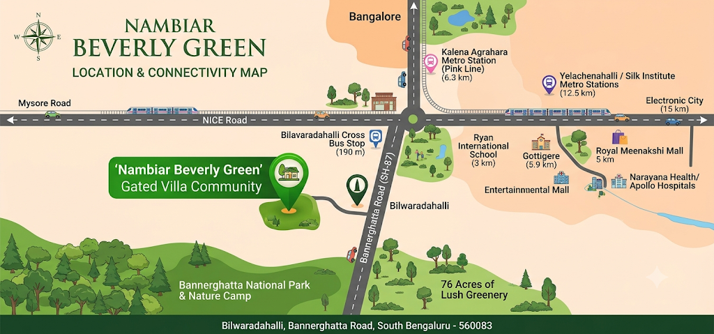
The Nambiar Beverly Green Map shows a big 76-acre gated villa community at Bilwaradahalli on Bannerghatta Road (SH-87) in South Bangalore. You can find it on Google Maps at the exact GPS points of 12.823744° N and 77.571837° E. This project is in a great spot where city roads meet the green forest of Bannerghatta National Park. On the site map, Phase 1 covers 36 acres and has 298 G+2 villa plots, wide inside roads, six green parks, and a big 60,000 sq. ft. clubhouse. On the road map, the project connects north to JP Nagar and the city center, east to Electronic City through NICE Road, and sits just 3 km north of the Bannerghatta Nature Camp.
Understanding the Nambiar Beverly Green Location Map
Reading the location map for this project is very easy because one main road—Bannerghatta Road (State Highway 87)—connects the whole area. Every daily drive, metro station, and highway link starts from this main road.
- North Direction (City & Daily Needs): Going north takes you straight through Gottigere, Hulimavu, and JP Nagar into the middle of Bangalore. All top schools, big hospitals, shopping malls, and the upcoming Pink Line Metro station are on this side.
- East Direction (IT & Office Hubs): A short drive north takes you to the NICE Road entry near Gottigere. Going east on NICE Road gives you a fast, traffic-free drive straight to Electronic City and Hosur Road.
- South Direction (Nature & Forest Area): Right to the south of the project is the green forest of Bannerghatta Biological Park and the Nature Camp (3 km away). This means you get fresh air, green views, and no tall buildings blocking the south side.
- West Direction (Link to Mysore Road & Tumkur Road): Taking the NICE Ring Road to the west connects you easily to Kanakapura Road, Mysore Road, and the highway going to the airport.
Transit & Connectivity Highlights on the Map
For home buyers checking travel times on the Nambiar Beverly Green Map, the project gives easy access to roads, metro trains, buses, and the airport:
- Highway Network: State Highway 87 runs right past the project for 45 km. It connects straight to the NICE Ring Road at Gottigere and the Outer Ring Road (ORR) at Jayadeva Hospital.
- Metro Access: The closest upcoming metro is the Kalena Agrahara Metro Station (Pink Line), which is 6.3 km north on Bannerghatta Road. Also, the working Green Line stations at Yelachenahalli and Silk Institute are about 12.5 km away.
- BMTC Bus Network: You can catch a bus right outside the main gate. The Bilwaradahalli Cross bus stop is just 190 meters away. Regular city buses to Majestic and a direct airport bus (KIA-14A) start from Bannerghatta Circle, just 2.3 km away.
- Kempegowda International Airport: The airport is 68 km north. You can reach it through the city center or take the faster NICE Road to Tumkur Road route.
Nearby Landmarks Marked on the Map
A good home location needs shops, schools, and offices nearby. The area map around Nambiar Beverly Green shows top places just a short drive away:
| Category | Key Landmarks on the Map | Distance / Direction |
|---|---|---|
| IT & Tech Parks | Jigani Tech Hub, Electronic City, Kalyani Magnum Tech Park, IBC Knowledge Park | 10 km to 15 km (East & North) |
| Schools | Ryan International School, EuroSchool Bannerghatta, Chrysalis High, DPS South, NPS JP Nagar | 3 km to 10 km (North & Northwest) |
| Hospitals | Medax Hospital Gottigere, Noble Hospital, Narayana Nethralaya, Fortis, Apollo Hospital | 5.9 km to 11 km (North) |
| Shopping Malls | Royal Meenakshi Mall, Nexus Vega City Mall, Forum South Bengaluru, M5 E-City Mall | 7 km to 15 km (North & East) |
| Nature & Leisure | Bannerghatta Nature Camp, Bannerghatta National Park | 3 km (South) |
Inside the Site: Nambiar Beverly Green Master Plan Map
While the road map shows outside streets, the master plan map shows how the 76-acre land is planned inside the gate. About 50% to 80% of the land is left open for parks, trees, and wide roads, so the area feels quiet and open.
- Entrance Plaza & Retail Block: Everyone enters through a big main gate on the main road. The map shows a shopping area for daily needs and a safe school bus pickup spot right at the entrance. This keeps delivery trucks, outside shoppers, and school buses away from the homes inside.
- Wide Internal Road Network: The main roads inside the project are 12 meters to 12.19 meters wide (about 40 feet), and the smaller lane roads are 9.14 meters wide (30 feet). This gives plenty of room for two-way car driving, shady walking paths, and guest parking without traffic jams.
- Phase 1 Villa Plot Distribution: Spread over 36 acres, Phase 1 has 298 G+2 villa plots (with villa sizes from 3,732 to 4,638 sq. ft.). The map has an almost equal number of East-facing (151 plots) and West-facing (147 plots) homes across main plot sizes:
- 35 × 55 ft plots (1,925 sq. ft.): 135 plots
- 40 × 63 ft plots (2,520 sq. ft.): 59 plots
- 36'9" × 55 ft & 41'10" × 63 ft sizes: 40 plots
- Corner and odd-sized plots: 64 plots
- Six Southern Landscaped Parks: Along the whole south border of the Phase 1 map, the builder has planned six green parks. This creates a green wall of trees and gives walking tracks for every lane.
- The 60,000 Sq. Ft. Clubhouse: Placed in a spot that is easy to walk to from all villas, the two-floor clubhouse has indoor games, a gym, swimming pools, and party areas.
Why Reading the Map Matters Before Booking a Villa
Looking closely at the Nambiar Beverly Green Map before you buy a villa helps you pick the best spot for your family:
- Picking the Right Plot Facing: Since East and West plots are shared equally on the map, you can easily pick a Vastu-friendly home that gets good morning or evening sunlight.
- Checking Border Lines: Looking at the approved site map helps you check plots near the south border (where a 220 kV power line sits behind the six parks) and compare them with plots in the middle of the layout.
- Choosing Between Quiet Spots and Quick Exit: Plots near the front gate let you get out to Bannerghatta Road very fast, while plots deeper inside near the six parks give you more quiet and greenery.
Frequently Asked Questions (FAQs)
1. Where exactly is Nambiar Beverly Green located on the Bangalore map?
Nambiar Beverly Green is at Bilwaradahalli on Bannerghatta Road (SH-87) in South Bangalore, Karnataka – 560083. It is just 3 km north of the Bannerghatta Nature Camp.
2. What are the exact GPS coordinates on the Nambiar Beverly Green Map?
The exact GPS numbers for the project on the map are 12.823744° N latitude and 77.571837° E longitude.
3. How much land does the Nambiar Beverly Green master plan map cover?
The full project map covers 76 acres of land. Phase 1 covers 36 acres and has 298 luxury 4 BHK villa plots.
4. Which is the nearest metro station to the Nambiar Beverly Green location map?
The Kalena Agrahara Metro Station on the new Pink Line is the closest station, located 6.3 km north on Bannerghatta Road. The working Silk Institute and Yelachenahalli Green Line stations are 12.5 km away.
5. How far is Electronic City from Nambiar Beverly Green by road?
Electronic City is about 15 km east of the project. You can reach it fast by taking the NICE Ring Road at Gottigere.
6. What plot sizes are shown on the Nambiar Beverly Green Phase 1 layout map?
The Phase 1 map mainly has 35 × 55 ft (1,925 sq. ft.) and 40 × 63 ft (2,520 sq. ft.) villa plots, along with some wider plots and corner plots, in both East and West facings.
7. How wide are the internal roads inside the Nambiar Beverly Green layout?
The site map has wide 12-meter and 12.19-meter main roads and 9.14-meter lane roads, along with tree-lined walking paths and a school bus bay at the main gate.